Thursday, May 27 was the first official day of the Great Cretaceous Walk, with some great walking on and by some great Cretaceous rocks from then through today, Sunday, May 30. Just before we started walking, though, Tom (Rich) and I drove from Melbourne to Inverloch, Victoria, which took about two hours. Once there, we checked into the Inverloch Motel, which is such a quaint and old-fashioned motel that it does not have Internet access: hence the lack of entries for the past four days. (Many thanks to Lesley and Gerry Kool for offering their wireless to post this!)
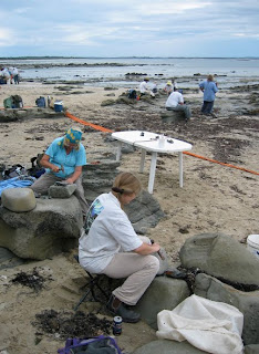
Flat Rocks (Tom Rich sitting to the left).
After that and lunch, the first place we visited, and where the walking began, was Flat Rocks. Our start here was appropriate for several reasons. One is that this is a of classic fossil locality in Australia, the site of the annual Dinosaur Dreaming dig site. Each January-February, Monash University and the Museum of Victoria have organized a 4-6 week volunteer-driven excavation of a rock layer that contains the remains of dinosaurs, mammals, and other Cretaceous animals.
Volunteers at Dinosaur Dreaming dig site in February 2006.
This dig requires major effort, in that the rock is very hard – sometimes requiring jackhammers and other power tools, but normally using hand tools – and the site is underwater twice daily from the tides. During those times of high tides, many kilograms of rock are transported to an offsite location, where volunteers break up larger chunks into much smaller ones (“sugarcube” sized), looking for small bones and teeth. This is not the type of dinosaur dig where complete and fully articulated skeletons emerge; rather, bits and pieces are the norm. Despite the name “Dinosaur Dreaming,” by far the most valuable fossils found here are tiny mammal jaws, some of which provide insights on the early evolution of mammals in Australia.
As my faithful readers may already know, Flat Rocks is also the place where four years ago I found fossil crayfish burrows, the first known Mesozoic crayfish burrows in Australia, as well as two partial dinosaur tracks. A dig-site volunteer then found a third dinosaur track the following year. This place is also near the easternmost extent of Cretaceous rocks along the Victoria coast, so it was a good place to start as we move from east to west.
Flat Rocks and an area just east of it, called The Caves, took up Thursday afternoon (May 27). All day Friday (May 28) was spent walking around the area of Eagle’s Nest and Shack Bay, just west of Flat Rocks. On Saturday (May 29), we went a little further west of Eagle’s Nest to Shack Bay (again), Twin Reefs, and the eastern half of The Oaks. The timing of the tides conspired with strong waves on Sunday (May 30) to limit our field work to the morning. Regardless, much was accomplished, as we traversed the western part of The Oaks, then went further west to outcrops along Undertow Bay and Cape Paterson.
Eagle’s Nest.
Eagle’s Nest is named about the prominent and photogenic erosional structure there, and is an easily visible landmark in the eastern part of the Cretaceous coastal outcrops.
Shack Bay.
I’m not sure what Shack Bay is named after, as I saw no shack, although it definitely is a bay.
Twin Reefs.
I’m assuming Twin Reefs has two reefs offshore, unless this name is used as some sort of Australian metaphor to which I am not privy.
The Oaks, eastern portion.
The Oaks, western portion (with a beach in between the two outcrops).
No oaks were seen at either half of this locality, although a few fossil trees from the Cretaceous were preserved in the rocks there.
Undertow Bay.
We are guessing that the name of Undertow Bay tells visitors that it is not the best place to go for a swim. Walking along this outcrop had an adventurous feel to it, no doubt encouraged by the waves smashing against the rocks all around us.
Cape Paterson.
Cape Paterson was a bit more genteel than Undertow Bay, but still wild and wooly in spots. Fortunately, it had relatively easy access and wide platforms just below the cliffs. Still, the oncoming high tide led to a hasty retreat, so field work on Sunday was cut short.
So why am I doing this again? The main goal of The Great Cretaceous Walk is to document more trace fossils and note their locations in the Cretaceous rocks of the Victoria coastline. This mostly involves a combination of old-fashioned walking and looking for the right search images, which is how paleontology has been done for the past 200 years.
But in this case, it is being done with a modern technological twist. I have been using a GPS (global-positioning system) unit to record the locations of each trace fossil I encounter. This is done by leaving the GPS device on during each excursion, then using it to mark the place of each trace fossil as a “waypoint.” In a notebook, using a pencil (yes, that’s old-fashioned, too), I’ve written the waypoint numbers (001, 002, etc.), noted what trace fossil was there, and photographed them with a digital camera (that’s another modern technological twist). Later, I will correlate the recorded times on the GPS unit with those of the digital photographs, and the waypoints will be put into a GIS (geographic information system) file so that these can be placed on a digital map. At least, that’s my hope!
How is it going? Pretty good, although most of the trace fossils consist of probable crayfish burrows of various shapes, sizes, and preservational modes. Most are filled with sandstones that are colored differently from the surrounding sedimentary rock, which sometimes helps me to spot these trace fossils from more than 10 meters (33 feet) away.
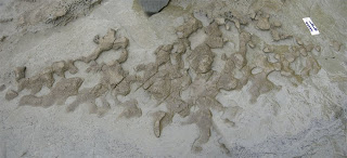
But for me to record these as trace fossils, they must fulfill some strict descriptive criteria. For example, here is an excellent example of one of the probable crayfish burrows, showing a beautifully expressed horizontal network, branching tunnels, enlargements between branches, connections to vertical shafts and consistently sized tunnels.
Fossil crayfish burrow from the Strzelecki Group, about 115-120 million years old: view is looking down onto the horizontal expression of the burrow system. Scale is about 15 cm (6 inches).
In fact, paleontologists have a name for a trace fossil with this form: Thalassinoides. We give formal names to trace fossils for better communication with one another, although the names normally have nothing to do with the animal that made the trace fossil.
So far, I have recorded more than 25 locations with Thalassinoides, which is not bad for about three days of field work. However, sadly – just short of tragically – long stretches of these coastal exposures have no visible trace fossils at all. For one, dinosaur tracks, which are common in some Jurassic and Cretaceous rocks of the American West, are annoyingly absent from nearly everywhere we’ve looked so far. Also, in three days of walking, Tom Rich and I have not seen a single dinosaur bone – or any other fossil bone for that matter.
Why are both dinosaur tracks and bones so rare here? I (and others) suspect that this circumstance is related to the environments that produced these rocks 115-120 million years ago. And that is the subject of the next entry…


Chiboogamoo! So glad you've found internet connection and were able to post this most recent entry! Hallelujah is particularly fascinated by the photographs of the Cretaceous rocks along the coasts and your discussion of their "place" names. How odd it is that we humans name a place after something that causes us to mentally afix the place and name together. Why are there so many Peachtree streets in Atlanta when there are no visible signs of peach trees?
ReplyDeleteI am also pleased that you are using this "new" technology and look forward to seeing the results of the GPS and digital photos...what will that reveal? Missing you, with love, HT
glad to see you're keeping out of trouble:)
ReplyDeletethat you are using this "new" technology and look forward to seeing the results of the GPS and digital photos...what will thatflat roofing options
ReplyDeletethat you are using this "new" technology and look forward to seeing the results of the GPS and digital photos...what will thatflat roofs do
ReplyDelete